GIA LAI PROVINCE
Square: 15536,9 km2
Population: 1300,9 thousands people (2010)
City: Pleiku City
Districts: An Khe Town, Ayun Pa Town, Chu Pah, Chu Prong, Chu Se, Duc Co, Ia Grai, Kbang, Krong Pa, Kong Chro, Mang Yang, Dak Doa, Ia Pa, Dak Po, Phu Thien.
OVERVIEW:
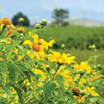
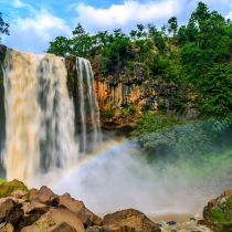
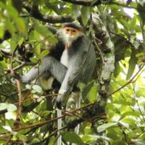
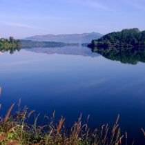
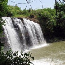
Gia Lai has many beautiful landscapes. Kon Chu Forest is a protected area for wild animals. Other sites include the Ayunpa military base and villages of Ba Na ethnic group. Coming to Gia Lai, visitors have a change to discover many impressive, poetic scenes. They are Kon Ka Kinh, Kon Cha Rang tropical forests, Xung Khoeng Waterfall, Phu Cuong Waterfall, Da Trang, Mo springs and Ayaun Ha Lake. Located on the top of an extinct volcano, Bien Ho (To Nung Lake) is called the 'Pearl of Pleiku'. Its water is so clear that visitors can see fish swimming under blue water.

Gia Lai Province - Vietnam Tourism
GEOGRAPHY:
Gia Lai is located in the Central Highlands. It shares the border with Kon Tum Province on the north, Dak Lak Province on the south, Cambodia on the west, Quang Ngai, Binh Dinh, Phu Yen provinces on the east.
Gia Lai is source of Ba and Se San rivers with Yaly hydroelectricity plant. It owns many springs, lakes, waterfalls, rives, and primary forest.
CLIMATE:
There are two seasons: the rainy season lasts from May to November and the dry season lasts from December to April. The annual average temperature varies between 21 and 25ºC. The west of Truong Son Ranges has annual average rainfall is 2,200 - 2,500mm. The east of Truong Son Ranges has annual average rainfall is 1,200 - 1,750mm
TOURISM:
Coming to Gia Lai, visitors have a change to discover many impressive, poetic scenes. They are Kon Ka Kinh, Kon Cha Rang tropical forests, Xung Khoeng Waterfall, Phu Cuong Waterfall, Da Trang, Mo springs and Ayaun Ha Lake. Located on the top of an extinct volcano, Bien Ho (To Nung Lake) is called the 'Pearl of Pleiku'. Its water is so clear that visitors can see fish swimming under blue water.
The province is also proud of funeral houses, La Phum, D'ko Tu traditional villages with special Rong house. Whenever going to this windy and sunny land, visitors are likely to see the unique architectural style of the statues in funeral houses, and to investigate the local customs and practice mysterious to them. Apart of that, tens of thousands of visitors are attracted to Dong Xanh Cutural Park in which many typical varieties of flowers and trees of Central Highlands are planted.
Gia Lai has historic sites such as King Quang Trung's guerilla base, Nup hero's homeland, Pleiku Prison, Pleime, Cheo Leo, and La Rang battlefields.
TRANSPORTATION:
Pleiku is 186km from Quy Nhon, 197km from Buon Ma Thuot, and 550km from Ho Chi Minh City.
Vietnam Airlines has daily from Da Nang and Ho Chi Minh City to Pleiku Airport. Pleiku Airport is 25km from Pleiku City centre, 45km from Kon Tum.