CA MAU PROVINCE
Square: 5331,6 km2
Population: 1212,1 thousands people (2010)
City: Ca Mau City
Districts: Dam Doi, Ngoc Hien, Tran Van Thoi, Cai Nuoc, U Minh, Thoi Binh, Nam Can, Phu Tan.
OVERVIEW:
Ca Mau is a city located in southern youth of our country, formation and development from the town of Ca Mau in the early 20th century the town of Ca Mau and Ca Mau City today. Development process including the contribution of large communities of ethnic, makes mark on history emergency wild. The cultural value that is invaluable to potential tourists still leave unanswered.

Ca Mau province - Vietnam Tourism
GEOGRAPHY:
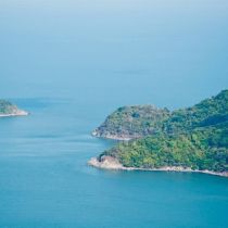
Ca Mau Province is situated in the southern tip of Vietnam with 307km coastal length. It is surrounded by East Sea on three faces and Kien Giang, Bac Lieu provinces on the north and north-east.
It's interlacing rivers and canals have generated tangled flows in the province. Seven large rivers are: Ong Doc, Bay Hap, Cai Lon, Ganh Hao, Dam Doi, Trem Trem, and Bach Nguu. Some offshore islands are: Hon Da Bac, Hon Khoai and Hon Chuoi.
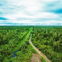
There are two types of forest in Ca Mau province: salt marsh and cajuput. The cajuput forest has the highest biological value among other types of natural forest, with high economic value and environmental protection.
CLIMATE:
Ca Mau, with its sub-equatorial monsoon climate has two main seasons: the rainy season from May to October, and the dry season, extending from November to April of the next year. The province is average annual temperature is 26.5ºC. It is coolest in January with 25ºC. The annual rainfall averages 2,500mm, 90% of which is distributed over 6 months of the rainy season. Average humidity is about 80% in dry season and 85 % in rainy season. Ca Mau rarely suffers storms and floods.
TOURISM:
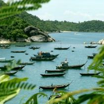
Ca Mau has great potentiality in ecological tourism thanking to salt-marsh ecological systems and diversified plants and animals. It has long seaside so there are many shrimp farms here. Then it is considered one of the key fishing grounds of the country, with great reserves of seafood of different types. Besides that, there are wild animals, such as deer, pig, and monkey.
Hon Khoai Island is a historical vestige that had related with the insurrection led by hero Phan Ngoc Hien. Ca Mau is famous for U Minh cajuput forest and Nam Can mangrove forest.
Rather than those, Ca Mau is also well known for its bird sanctuaries: Cai Nuoc, Dam Doi, Ngoc Hien... Most of all, Ngoc Hien bird sanctuary attracts more and more visitors.
TRANSPORTATION:
By Road: Ca Mau is 114km from Bac Lieu, 130km from Rach Gia, 180km from Can Tho, and 380km from Ho Chi Minh City. National Highways No. 1A, 63 connect Ca Mau to Bac Lieu and Kien Giang provinces.
By Waterway: The boats run from Ca Mau to Ho Chi Minh City, Rach Gia. Tourist can visit U Minh and Ngoc Hien by ferry.