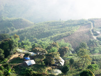
A poor and remote spot in the northern province of Thanh Hoa, Sai Khao is a favored destination among Vietnamese backpackers for its magnificent views and simple, kind people.
In backpacker circles, there is a lot of shaking of the heads. They are sad that the historic and picturesque Mai Chau – Muong Lat – Sai Khao route is going to be closed, because work will soon start on the Trung Son Hydropower Plant, a project aided by the World Bank in Thanh Hoa Province.
The route, which starts in Mai Chau District in Hoa Binh Province, goes through Thanh Hoa’s Muong Lat District and ends in Sai Khao, was used by the famous military unit Tay Tien (westwards) in 1947 when they were assigned to join hands with Laos in fighting the French colonialist forces.
We decided to revisit Sai Khao and once gain go on the historic route of Tay Tien, well-known thanks to a poem of the same name.
One of the poorest villages of Muong Lat, Sai Khao “welcomes” tourists with rough and long, sometimes seemingly endless, slopes. In fact, many bikes in our group broke down on Pu Hin Hai, the longest and highest slope. Some members who rode pillion had to get off and push their vehicles to get to the top.
But when we reached the village of 390 mostly H’Mong residents, we were glad that we made the effort to make it here.
Dubbed the “Da Lat town of Thanh Hoa,” Sai Khao has a cool atmosphere with air so unpolluted it seems to have a bite when you breathe. Since it is the highest point in Muong Lat, which is some 700 meters above the sea level, travelers can take in a panoramic view of high mountains and sky, as well as the H’Mong people’s green terraced fields of corn and rice. You do not need a photograph…it is a sight that will never fade from your mind.
Sunrise and sunset in Sai Khao are unforgettable experiences as well. Early in the morning, after rains, clouds embrace mountain tops and everything is bathed in a golden light.
Nights in Sai Khao are almost pitch dark, because there is no electricity, only lights from candles, oil lamps and stars. This also means that we get the rare chance to observe stars closely without a telescope or hindrances of high buildings.
Even though Sai Khao has almost nothing – no water supply, no telecommunications, no faved roads and not even a market, the village makes up for it with what many tourism destinations in Vietnam are losing: kind and simple-hearted people.
In Sai Khao, a young lady who ran a small café gave us fresh bamboo shoots so we could “improve” our meals, while an old ice-cream seller gave us extras without charging. Getting lost was never a problem, just another opportunity to interact with residents who always had time and patience to give.
The pure laughter of local children who go to school on bare feet, sometimes without proper attire because they are too poor, will stay with us forever. Their school was built from three almost-torn down houses and a few wooden planks.
Many Vietnamese backpackers keep revisiting the Village, charmed by the people and their children, carrying clothes, goods, books, notebooks and other things donated by others to give to locals.
The route
The Tay Tien route starts in Mai Chau District’s Ban Lac Village, which is some 140 kilometers from Hanoi. Travelers can take a bus at the capital’s My Dinh Bus Station. Or go by motorbike and follow the National Road 6.
From Ban Lac, follow Road 15A to reach Co Luong Town, also part of Hoa Binh. In Co Luong, go along the Ma River to reach Hoi Xuan Town, Quan Hoa District, Thanh Hoa Province. After that, go along Road 520, for 112 kilometers to reach Muong Lat.
Sai Khao is 15-18 kilometers from Muong Ly Commune, Muong Lat.
The whole trip from Hanoi to Muong Lat is some 420 kilometers, and full of challenges. Travelers should expect to meet numerous bridges made from bamboo and wood. They cross over rivers, streams and rocky creeks.
The path to Muong Lat is tough, with tortuous sections that run along the mountains. Moreover, some of them have been hit by landslides and rockslides over the years, so after rains, they become almost impossible, even for experienced drivers, to ride on.
It was lucky that the day of our trip was sunny, but since some parts of the road were under construction, we had to cross the Ma River to change our route. The thrill (and fear) of being on a bamboo raft crossing the fierce river is, as they say, “something else.”
In the end, the risks are worth it, as the trip delivers innumerable delights.
At some parts, for example, the road is bigger and decorated with bamboo barriers that local people make to protect their terraced fields.
The ubiquitous presence of bamboo in Muong Lat is part of its unique charm. Along the road, sometimes we went through bamboo forests, but sometimes it looked as they we were going above them.
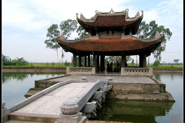
Source: Thanhniennews
(84-63) 3 826042 – (84-63) 3 511142
No 54 Nguyen Dinh Chieu, Ham Tien Central Mui Ne Beach Binh Thuan Vietnam
523 To Hien Thanh District 10 Ho Chi Minh City Vietnam
Ha Long Halong City Quang Ninh Vietnam
A13 Hung Thong 2 Halong City Quang Ninh Vietnam